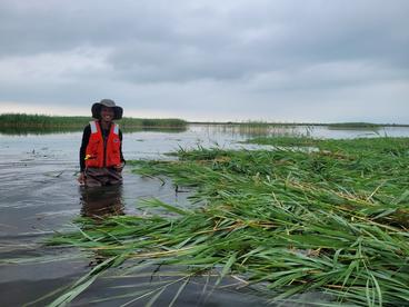
Recent low water events have fueled expansion of the non-local Phragmites australis.
Challenge: Water level fluctuations in the Great Lakes Basin are intensifying in frequency and magnitude, directly impacting non-local plant management decisions and outcomes.
Principal Investigator(s):
- Wesley Bickford (USGS - GLSC)
Co-Investigator(s):
- Kurt Kowalski
- Andrew Strassman
Cooperator/Partner(s):
- Hans W Vraga (Upper Midwest Water Science Center)
- Jason Rohweder (Upper Midwest Environmental Sciences Center)
Water levels in the Great Lakes are fluctuating in ways that we have not seen in the past, with both historically low- and high-water levels occurring in the last decade. Expectations are that larger and more frequent water-level fluctuations will occur in response to climate change. The increased variability in lake levels has implications for the management of invasive plants found in the coastal wetlands that surround the Great Lakes, with some species benefiting from periods of low water levels. Phragmites australis, a prominent invasive grass that disrupts fish and wildlife habitats, thrived during the most recent period of low lake levels. However, periods of high lake levels could provide managers with opportunities to “drown” Phragmites stands by cutting them below the waterline, a process which depletes the plants of oxygen. This is a promising strategy that is the subject of ongoing USGS research.
However, identifying the time and place to devote limited management resources towards invasive plant management is a challenge for managers. The goal of this project is to develop a decision-support tool that combines data on Phragmites occurrence, topography, lake depth, and water level projections to predict where Phragmites could invade during future periods of low water and identify areas where stand management can be targeted during future periods of high-water levels. Products will include an interactive geonarrative and a customizable online tool for decision-support and prioritization of Phragmites management in the Great Lakes basin. Specifically, the tool will allow managers to visualize how fluctuating lake levels impact habitat suitability for Phragmites, thus helping to identify areas to prioritize for management, given projected water levels. Although the initial work of this team will focus on Phragmites, the products will be deliberately transferable to other species of interest for invasive species management or habitat restoration.
Read more from the CASC Project Explorer.
